

Incoming Pampero Cold Front Set to Bring Sharply Lower Temperatures
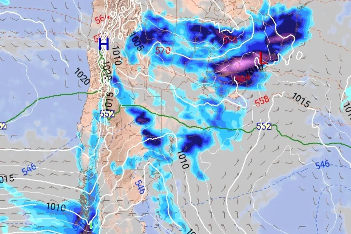
A shift in weather conditions will bring a southwestern wind known as the pampero, bringing rain and a sharp temperature drop.
Weather Shift and the Arrival of the Pampero
A noticeable transition in atmospheric patterns is set to deliver southern winds, precipitation, and a significant cooling trend across the metropolitan area. Following a mild and clear Thursday, the movement of a cold weather system will introduce weekend conditions more typical of a different season during the early morning hours.
The cooling effect will impact the suburban districts most severely, where Sunday morning lows are projected to settle between 7 and 9°C. Prior to that, Saturday will feature strong gusts reaching up to 60 km/h alongside maximum figures remaining under 20°C. Afterwards, a gradual thermal recovery is expected under sunny skies.
How the Pampero Alters Regional Conditions
According to forecasts from Meteored, the pampero functions as a southwestern wind capable of generating gusts up to 40 km/h while clearing out cloud cover. Its arrival signals the conclusion of an initial round of regional instability that previously brought scattered downpours and isolated storms with uneven distribution.
While Thursday maintains pleasant attributes with a high of 25°C, that stability remains temporary. Friday afternoon and evening will witness advancing colder air originating from Patagonia, carrying a 90% probability of precipitation, though expected accumulation amounts remain low. Following this system, winds will shift southward with stronger gusts.
Weekend Forecast and Temperature Lows
Saturday opens under overcast skies and potential light rain in southern and western sectors. Although cloud cover will thin by afternoon, temperatures will fail to bounce back immediately, holding steady between 18 and 19°C alongside brisk southern winds.
- Sunday morning presents the chilliest phase of the cycle.
- City readings will dip to between 10 and 11°C.
- Suburban areas will experience lows spanning 7 to 9°C, with the northern sector registering the coldest conditions.
As the daytime progresses, sunshine will assist a thermal rebound, pushing highs up to 23°C and creating a pronounced thermal amplitude between dawn and afternoon.
Sources: La Nación, Minutouno, Revista Chacra.
Frequently asked questions
What is the pampero?
How low will the temperatures drop?
When will the cold weather arrive?
What weather is expected on Saturday?
Related stories

Rinky Hijikata Upsets Novak Djokovic at Paris Masters to End Serb's Season
Qualifier Rinky Hijikata secured a stunning win over Novak Djokovic at the Paris Masters, bringing an end to the veteran player's season and ATP Finals hopes.

Central Andhra Pradesh Floods and Twin Cyclones Damage Assessed
Following consecutive natural disasters linked to central andhra pradesh floods, state leaders have urged the Union government to evaluate the cumulative impact of twin cyclones.
എല് നിനോ Brings Severe Drought to Kerala, Threatens Crops and Water Reserves
Heavy rains have failed across northern India, and Kerala faces a sharp drop in reservoir levels, reduced crop yields and rising food prices due to എല് നിനോ.

Paraguay President Resigns Amid Ueno Bank Collapse and Political Crisis
President Santiago Peña stepped down as Paraguay’s leader after Ueno Bank’s failure left millions of citizens without access to their savings, sparking protests and an impeachment…