

Understanding the Early Disruption Affecting the Weather Polar Vortex
The polar vortex has experienced a record-early disruption in the calendar year. Experts explain what this unusual atmospheric event means for upcoming conditions.
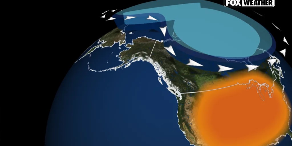
Understanding the Record-Breaking Weather Polar Vortex Disruption
The weather polar vortex has experienced a major disruption at the earliest point in a calendar year on record. This unprecedented atmospheric breakdown has sparked questions about what changes might follow across North America.
The polar vortex consists of a band of powerful winds circling the North Pole, positioned roughly 10 to 30 miles above the Earth around 55 degrees north latitude. Seasonal weather patterns in the lower atmosphere can push atmospheric waves into the stratosphere, which can weaken, split, or displace the circulation.
What Causes a Disruption?
When atmospheric waves from the lower atmosphere are strong enough, they travel upward into the stratosphere. These waves can disrupt the circulation of the polar vortex, and in some cases, even reverse its normally strong westerly winds.
While this phenomenon can alter atmospheric circulation and increase the chances of Arctic air spilling southward, analysts emphasize that it does not translate into immediate temperature drops at the surface.
Potential Impacts and the Role of El Niño
Changes happening high in the stratosphere take several weeks to work their way downward to influence the jet stream and larger weather patterns. Therefore, any potential cold-weather impacts across North America would likely take several weeks to develop, pointing more toward late November or December.
At the same time, a rapidly strengthening El Niño climate pattern is playing a major role. This developing Super El Niño is actively strengthening the Pacific jet stream, carrying mild air and storms across the country. Forecast models continue to favor above-average temperatures across much of the northern United States through December, with the coldest air currently pooling across Eastern Europe and Siberia.
Sources: FOX Weather, CT Insider, The Telegraph.
Frequently asked questions
What is the polar vortex?
What happened to the polar vortex recently?
Does an early disruption mean immediate cold weather?
How is El Niño influencing current weather patterns?
Related stories
ಕರ್ನಾಟಕ ಹವಾಮಾನ ಮುನ್ಸೂಚನೆ: ರಾಜ್ಯದಲ್ಲಿ ಮಳೆ ಮತ್ತು ಒಣಹವೆ ವರದಿ
ಕರ್ನಾಟಕದಲ್ಲಿ ಹವಾಮಾನ ಮುನ್ಸೂಚನೆ ಪ್ರಕಾರ ನವೆಂಬರ್ 7 ಮತ್ತು 8ರಂದು ದಕ್ಷಿಣ ಒಳನಾಡು ಹಾಗೂ ಕರಾವಳಿಯಲ್ಲಿ ಮಳೆಯಾಗುವ ಸಾಧ್ಯತೆಯಿದೆ. ಉತ್ತರ ಒಳನಾಡಿನಲ್ಲಿ ಒಣಹವೆ ಮುಂದುವರಿಯಲಿದೆ.

U.S. Intelligence Flags Alleged Chinese Spy Connection for Jensen Huang
American intelligence agencies created a memo indicating that Nvidia CEO Jensen Huang had a romantic connection with an executive believed to be a Chinese spy.
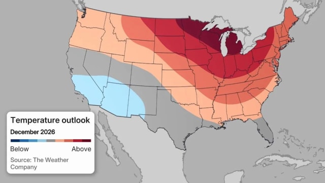
Climate Prediction Center Heavy Snow Map Shows States Facing Snow
The Climate Prediction Center’s new heavy‑snow map pinpoints a narrow Southwest band where colder‑than‑average temperatures raise the chance of significant snowfall, while most of…

Unusual Early Polar Vortex Disruption Stirs Weather Concerns
Forecasters report that the polar vortex is weakening unusually early, raising questions about potential winter cold blasts across North America.